Wednesday, June 16, 2010

Badlands National Park


Even though we were on somewhat of a schedule traveling from Washington to Michigan, we did allow ourselves enough time for a couple of unplanned side trips along the way. One that came up while we were in South Dakota was a brief stop at the Badlands National Park. I've never seen anything like this, and my first impression was this seemed like a landscape that belonged on another planet, or perhaps the setting for a movie like "The Lord of The Rings". Since that movie has already been made, maybe for an adaptation of Stephen King's "Dark Tower" series. It is stark, desolate, eerie, and other-worldly.


The park consists of nearly 244,000 acres of sharply eroded buttes, pinnacles and spires, and is really impossible to describe. The history of the Badlands stretches back to the beginning of time, and the land is rich with fossil beds dating 23 to 35 million years old. The evolution of mammal species such as the horse, sheep, rhinoceros and pig can be studied in the Badlands formations. An array of extinct animals, ranging from very enormous to very small, once ranged through the area now included in Badlands National Park. Some lived in the subtropical forests that flourished after the retreat of the shallow inland seas, while others inhabited the savannahs and grasslands that came in the years afterward.


Hopefully you can get at least a glimpse into this place like no other with the attached pictures. Remember - click on them to enlarge for the full effect.

Pierre, South Dakota


After leaving Rapid City, we continued our Eastward trek, with a two day stop near Pierre, South Dakota to visit the state capitol. Much to our surprise and delight, we were literally the only visitors there on the day we took our tour. It happened to be Sunday, and Mother's Day, and not very pleasant weather, so perhaps all those things combined made this an unlikely day for crowds. Since we were the only ones there, we were given a lengthy and private tour of the building by the docent on duty that day.


The first thing we noticed inside the building was the similarities to the construction and architecture to the capitol building in Helena, Montana. The architect did indeed pattern his design after the state capitol in Helena, with one major difference. The floor of the capitol building in Pierre is made of terrazzo tile. The floor is said to have been laid by 66 Italian artists. To give these artists a chance to place their signatures in the building (without allowing them to actually sign their names to the floor), each is said to have been given a blue stone to place in the floor. Only 55 of these tiles have been found, however. It is thought that the remaining stones may have been placed in locations now covered by walls, doors, or carpeting.


Here are some pictures of the outside, interior, and tile floor of the capitol building in Pierre.

Tuesday, May 11, 2010

Mt. Rushmore


Located in the Black Hills of South Dakota, the Mount Rushmore National Memorial is a monumental granite sculpture by Gutzon Borglum (1867-1941), and represents the first 150 years of the history of the United States with 60-foot sculptures of the heads of former United States presidents George Washington (1732–1799), Thomas Jefferson (1743–1826), Theodore Roosevelt (1858–1919), and Abraham Lincoln (1809–1865). The entire memorial covers 1,278.45 acres and is 5,725 feet above sea level. The memorial attracts approximately two million people annually.


We reached Rapid City on May 4th, very excited to finally get a chance to visit Mt. Rushmore. Although I had been here with my family during a cross-country vacation when I was 15, I only had a vague recollection of the experience. This was to be Dan's first visit, and we were both looking forward to the experience. The weather was unseasonably cold, and we woke on the morning of May 5th to a light dusting of snow in our RV Park. As we drove up to the memorial, snow continued to fall, and we were wondering how this would impact our viewing.


When we arrived, it was quite cold and overcast; fog had started to roll in, and the faces of the presidents were sometimes obscured by the swirling mists and the moisture that had collected on their stone likenesses. We took a few pictures, toured the visitor center, and watched a short film on the history of the monument before deciding to leave and try again the next day.

We had much better luck when we returned on May 6th. The air was clear (although still cold, and now windy), but our view was unobscured and we were able to really appreciate the full impact of this masterpiece, trying to capture the feeling in about 50 or more pictures. I've included just a few of the very best for your viewing.

Saturday, May 8, 2010

Devils Tower National Monument


After leaving Helena, our destination was Rapid City, South Dakota, to visit Mt. Rushmore. We planned to take two days to get there, as the mileage was a little long for a one day haul. On the second day, we only had a 4-hour trip on the schedule, so we decided to alter our route slightly and incorporate a trip to The Devils Tower National Monument, located in the Black Hills of South Dakota, standing 1,267 feet above the Belle Fourche River, 5,112 feet above sea level, and 867 feet from its base to the summit.

Devils Tower is made up of igneous rock, which is made directly from molten rock coming to the surface. Devil's Tower was a spire of molten rock that forced its way from deep inside the earth through the surface, or near to the surface. As time wore on, the sedimentary rock that surrounded the tower eroded, leaving Devil's Tower exposed. Sedimentary rock is much softer than igneous rock, thus it erodes faster. Devil's Tower was left standing tall when everything else had been blown or shifted away from it.


You may recognize the shape of Devils Tower from the 1977 movie Close Encounters of the Third Kind, where the top of the tower was featured as the landing pad for the aliens. The monument is located in a 1347 acre park featuring more than seven miles of hiking trails and is home to birds such as hawks, eagles, vultures, falcons and mammals such as white-tailed deer and the black-tailed prairie dog. More than 5000 climbers from all over the world climb the tower every year.


Devils Tower is a sacred site of worship for many American Indians and is known as Mato Tipila by the Lakota, which means "Bear Lodge". As Dan and I walked the 1.3 mile trail that skirts around the tower, we saw many prayer bundles tied to the surrounding trees. There were instructions at the beginning of the trail asking hikers not to disturb the prayer bundles as they are considered physical symbolic representation of prayers and are part of religious ceremonies. It's easy to understand how this could be a holy place. I was filled with respect for this massive monolith, and was struck with awe and wonder just standing in the presence of something so wondrous and mysterious.

Friday, May 7, 2010

Helena, Montana


We left Washington on May 1st, giving ourselves about two weeks to meander back to Hillman, Michigan, with stops along the way to three more state capitals: Helena, Montana, Pierre, South Dakota, and Madison, Wisconsin. We arrived in Helena on May 2nd, and toured the capitol and the town on the 3rd.


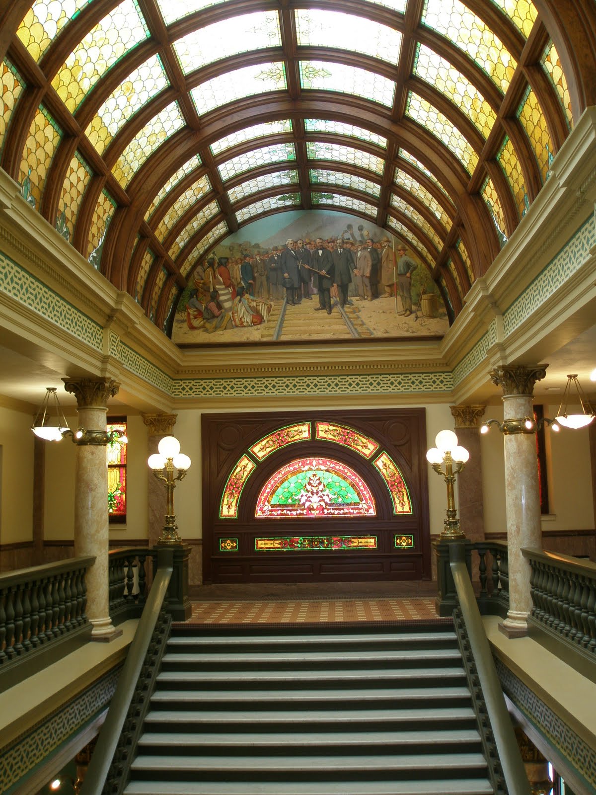
From the outside, the capitol building gave no hint of the beauty that lay hidden inside. Of the traditional dome style, the old and weathered building loomed gray against the cloudy skies, and I remember thinking that it could use a little TLC, something to perk it up a bit. But the minute we walked through the doors, it was like being transformed into another world. The beauty of the architecture, the stained glass windows, the long barrel vault skylight, the murals depicting the history of Montana, and the intricate details found in every corner you looked made it hard to tear your eyes away from one spot to the next. I hope the pictures I have posted will speak for themselves. (Remember to click on the picture to enlarge it!)

I had always pronounced "Helena" as "HeLEEna" but as we soon found out, the correct pronunciation is actually "HELena", and when I looked this up on the web, I found an entertaining story of how this came about. Here is the clip from Wikipedia on the origin of the name, and how it is pronounced today.

"Helena was founded with the July 14, 1864 discovery of gold in a gulch off the Prickly Pear valley by the "Four Georgians", who were gold prospectors. The city's main street is named Last Chance Gulch and lies close to the winding path of the original gulch through the historic downtown district.

The original camp was named "Last Chance" by the Four Georgians. By fall, the population had grown to over 200 and the name "Last Chance" was viewed as too crass. On October 30, 1864, a group of at least seven men met to name the town, authorize the layout of the streets, and elect commissioners. The first suggestion was "Tomah," a word the committee thought had connections to the local Indian people of the area. Other nominations included Pumpkinville and Squashtown (as the meeting was held the day before Halloween). Other suggestions were to name the community after various Minnesota towns, such as Winona and Rochester. Finally, a Scotsman named John Summerville proposed "Helena," which he pronounced "hel-EE-na," "in honor of the heLEENa in Scott County, Minnesota..." This immediately caused an uproar from the former Confederates in the room who insisted upon the pronunciation HELena, after Helena, Arkansas, a town on the Mississippi River. While the name won, the pronunciation varied until approximately 1882 when the HELena pronunciation became dominant and has remained so to the present. Later tales of the naming of Helena claimed the name came variously from the Island of St. Helena, where Napoleon had been exiled, or was that of a miner's sweetheart."

Thursday, May 6, 2010

Family Visit (Washington)


After leaving Idaho, we started moving towards Elma, Washington for a family visit. My Mom lives in Montesano in an assisted care facility, and one sister lives close by. My other three sisters live in California, and we had planned for all five sisters to be in the area at the same time to visit with our mom, and with each other. Dan and I arrived at the Elma RV Park on a Friday and got settled in for the weeklong stay.


My daughter and two granddaughters live in Seattle, about 90 miles from the RV Park, so they drove down on Sunday for a visit. We took the opportunity for a surprise visit with my mom, and she was delighted to see not only her daughter, but also her granddaughter, and two great granddaughters. We spent the afternoon catching up and working puzzles in the facilities activity room.


My three sisters from California arrived later that night, and on Monday we all got together for the first of five days of visiting, reminiscing, and getting together with our mother. It isn't often that the five of us have a chance to be together, and even less often as time goes by. We all felt like we grew closer over this visit, sharing various aspects of our lives with each other, and gaining a new appreciation for one another. Having the opportunity to visit with mom all together, for several days in a row was a special treat for all of us.


My niece and her family also live nearby, and we were lucky enough to have them come for a visit one evening as well. It was a fun filled night of food, laughter, and music and came to an end much too soon.

Here are some pictures of this very special family visit.

Saturday, April 24, 2010

Boise, Idaho


My mother lives in Washington State, and as it turns out, three of my sisters from California were planning a trip up North for a visit in April or May. (I also have one sister who lives in Washington as well.) So, being in California in April meshed nicely into these plans and the sisters reunion will take place the last week in April. After making the decision to go back to Michigan, via Aberdeen, Washington, Dan and I decided we would take a round-about route the Pacific Northwest via Boise, Idaho so we could visit the Capitol. I also happen to have a niece (and her family) who live in Boise, so there was more than one reason to take this route.


We arrived in Boise on a Monday, and on Tuesday we met my niece for coffee at Big City Coffee, a very fun coffee, breakfast, and lunch place I recommend if you are ever in the area. Afterwards Dan and I toured the State Capitol, dropped by the natural foods CO-OP for lunch and a little shopping, then to the Old Idaho State Penitentiary for a self-guided tour of the prison that operated until 1973.

The Capitol, built in 1905, is of the traditional dome style, and was designed by John Tourtellotte, whose vision was to create a building that emphasized natural light and use it as a decorative element. He used light shafts, skylights, and reflective marble surfaces to capture natural sunlight and direct it to the interior space. For Tourtellotte, light was a metaphor for an enlightened and moral state government, and the building is referred to as the "Capitol of Light". Along with the natural lighting, the use of interior lights projects a soft golden glow throughout the building.


The atmosphere is formal and stately. Classic Doric, Ionic, and Corinthian columns support the rotunda, and the marble floors come from quarries in Alaska, Georgia, Vermont, and Italy. The columns themselves, although they look as if they are made from marble, are actually a finished surface composed of scagliola, a mixture of gypsum, glue, marble dust and granite, dyed to look like marble. Scaglioila originated in Italy during the 16th century as an alternative to marble, which was both expensive and very heavy.


I have included a few pictures of the "Capitol of Light" from our visit.

Wednesday, April 21, 2010

Sacramento, California March-April 2010


There will always be a part of me that considers the Sacramento area my home. I was raised from birth to age 18 in Orangevale, and spent the next 32 years living in various parts of Sacramento. I still have children and grandchildren that live in the area. And even though Dan and I travel full time all over the country, and live by the motto "Home is Where You Park It", both of us still have our regular doctors and dentists in the area. We have our favorite restaurants, and know where to go for just about anything we need. I am always excited when I think about coming to Sacramento, because I know I will see my family, and feel a sense of comfortable familiarity in my surroundings.

So, when I was twice the victim of thieves during my recent stay here, it was especially upsetting, and left me feeling sad and let down by what I think of as my home town. First my bicycle was stolen from the RV Park we were staying in, and it was cable locked at the time. It took the thief a few tries to cut through it, but eventually the deed was done and my bike was gone. A couple of weeks later, our truck, which was locked, was broken into and my purse with all the normal things you find in a purse, was stolen. The entire week following that was spent trying to diminish the repercussions of possible financial loss and identity theft. I know, I know… why did I leave my purse in the truck? Even if the door was locked? Don't think I haven't beat myself up over that one!


But the wondrous event that brought us here in the first place, and what really made it all worthwhile despite the bad luck, was the birth of my newest grandchild, Pearl Eve. This is my fifth grandchild, and I was lucky enough to spend time with all of them during our recent stay. Because seeing them can wipe away just about any sadness I might feel about anything else, I am dedicating the visit to Sacramento and these photos to them.

Friday, February 12, 2010

Skiing In Flagstaff, Arizona


Even though we are in sunny Arizona, we were delighted to take advantage of the snowy mountains in the Flagstaff area for a three day ski getaway. We tracked the weather for a couple of weeks, and when it looked like the conditions were most favorable, we booked a room in the "Ski Lift Lodge & Cabins", loaded up our gear, and headed out.

Flagstaff is about 145 miles from Surprise, with MapQuest giving us an estimated 2 hours 13 minutes on the road. We left Wednesday morning, wanting to arrive in Flagstaff about lunch time, then spend a couple of hours in the early afternoon getting the lay of the land before checking in to our room at the lodge. Before long, we ran into rain, and as we climbed, the rain turned to a rain-snow mix, and finally, just snow. There was also several feet of snow on the ground in and around Flagstaff.

After lunch, we checked out the Snow Bowl Ski Resort for down hill skiing and The Flagstaff Nordic Center for cross country skiing, our plan being to spend one day at each place. With so much snow on the ground, and the forecast calling for sunshine and clear skies the next couple days, we were anticipating a great couple days of skiing. We were not disappointed!

Thursday we headed to Snow Bowl. The snow conditions were perfect, the crowds manageable, and the weather in the morning was perfect. After lunch it started getting foggy, then the snow clouds followed the fog, and soon it was lightly snowing. We skied a while more, but when visibility kept diminishing, we decided to pack it in. It was a really fun first ski of the season.

Friday we drove to the Nordic Center where we spent the day cross country skiing. The weather was pristine! Clear blue skies, nary a breeze, and the sun shining off the snowy forest floor like sparkling diamonds. It was peaceful and quiet, everything blanketed in white, the snow absorbing the ambient sounds. Sometimes all you could hear was the swishing of the skis across the snow. Although we weren't the only ones there that day, at times that is how it seemed.

I've included some pictures the lodge, Snow Bowl, and the Nordic Center.

Sunday, January 17, 2010

White Tank Mountain Regional Park


The Phoenix area is not only a desert, it is also surrounded by numerous mountain ranges. To the northeast are the McDowell Mountains, to the west are the White Tank Mountains, and the Superstition Mountains lie to the east. The Sierra Estrella is southwest, and within the city itself are the Phoenix Mountains and the South Mountains. All these mountains are an easy drive from Phoenix and the suburbs, offering thousands of acres for hiking and biking. With the mild winter climate, this is the perfect time of year to explore these trails. So far Dan and I have taken a couple of hikes and one bike ride in the White Tank Mountains, about 18 miles away, an easy drive out of the city, located in White Tank Mountain Regional Park.


The park itself sprawls over 29,572 acres where the 4000-foot-high White Tank Mountains separate the Phoenix Basin of the Salt River Valley from the Hassayampa Plain. The mountains are steep, deeply serrated with ridges and deep canyons, and include fault lines. Floodwaters, pouring down chutes and dropping off ledges, have scoured out a series of depressions, or "tanks", in the white granite rock below, thus the name of the mountains. There is evidence of ancient Arizonans dating back 10,000 years, with hundreds of figures and symbols pecked on the rock faces of the Mountains.


Dan and I really enjoyed hiking and biking through the many varieties of cacti, including Barrel, Saguaro, Cholla, and Prickly Pear. Unfortunately this isn't the time of year when these cactus bloom, but then again - do I really want to be scaling a mountain with a 1300-foot elevation gain in 100 degree plus weather? Probably not!


Hope you enjoy these pictures of our most recent hike and bike ride in the White Tank Mountains Regional Park.